TBD Route 17 & Brewers Neck Rd | Carrollton, VA 23314
This feature is unavailable at the moment.
We apologize, but the feature you are trying to access is currently unavailable. We are aware of this issue and our team is working hard to resolve the matter.
Please check back in a few minutes. We apologize for the inconvenience.
- LoopNet Team
thank you

Your email has been sent!
TBD Route 17 & Brewers Neck Rd
Carrollton, VA 23314
James River Crossings Parcel H · Land For Sale · 1.24 AC

Investment Highlights
- Signalized access to Route 17 at Brewers Neck Road.
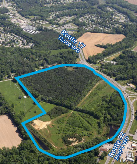
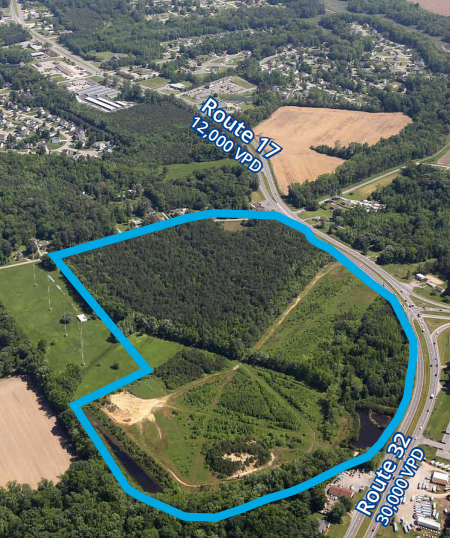
- Route 17 to Suffolk Line- 11,000 Vehicles Per Day.
- Route 32 to James River Bridge -29,000 Vehicles Per Day.
- Brewers Neck Road- 24,000 Vehicles Per Day.
Executive Summary
James River Crossings of Isle of Wight is a 62 acre prime commercial development parcel located at the signalized intersection of Route 17 (Carrollton Boulevard) and Route 32 (Brewers Neck Road) in Isle of Wight County. The property is well positioned to take advantage of the explosive residential growth in Isle of Wight. 28 acres will be developed by the land owners into multi-family. The remaining land will be allotted for commercial development. Isle of Wight, which is situated in the Hampton Roads MSA, is a rapidly growing middle-to-high income residential area. Access to the Peninsula and I-664 is by way of U.S. 17 James River Bridge through the City of Newport News. U.S. 17 to the south connects the proposed site to the rapidly growing communities in Suffolk, Virginia. There will be over 200,000 people living within ten (10) miles of the proposed site with a daytime population of 204,161. Currently around 29,000 vehicles travel daily on U.S. 17 in front of the proposed site. Brewers Neck Boulevard carries around 24,000 vehicles per day through the intersection of U.S. 17.
PROPERTY FACTS
1 Lot Available
Lot
| Price | $1,220,983 CAD | Lot Size | 1.24 AC |
| Price Per AC | $984,663.31 CAD |
| Price | $1,220,983 CAD |
| Price Per AC | $984,663.31 CAD |
| Lot Size | 1.24 AC |
BMP's in Place. All public utilities are located at the site or along Route 17 in front of the site.
zoning
| Zoning Code | GC |
| GC |
1 of 2
VIDEOS
3D TOUR
PHOTOS
STREET VIEW
STREET
MAP

